
The Char Dham Yatra is four roads that fail in four different ways. The Kedarnath road loses its last five kilometres to a slide above Sonprayag. The Badrinath road loses its only approach at Sirobagad, twenty kilometres before Rudraprayag — and takes Kedarnath traffic with it, because both dhams share that stretch. The Gangotri road slides at Nalupani and Dabrani in the narrowest part of the Bhagirathi gorge. The Yamunotri road, the least finished of the four, washed away a hundred metres of itself at Syanachatti in July 2026 and cut the shrine off for two days.
Short answer: the 2026 season shut the yatra three times — 20 July, 28–29 July and 26–27 September — and at its worst the state had 111 roads closed, including three national highways. But no highway on the circuit stayed shut longer than about two days, and the closures that ruin itineraries are the unannounced six-to-twenty-four-hour ones no order is issued for. For 2027, add two buffer days if you travel in July or August, one in September, none in May–June — and check the road at 6:00 AM on the day you drive, not the night before.
Last verified: 11 November 2026 — against the Garhwal Commissioner’s suspension orders, State Emergency Operation Centre bulletins carried by ANI, The Hindu and The New Indian Express, MoRTH’s landslide-mitigation release of 12 June 2026, PIB’s Char Dham programme figures and the temple committees’ 2027 opening announcements. The 2026 season closed at Kedarnath and Yamunotri on 11 November and closes at Badrinath on 16 November.
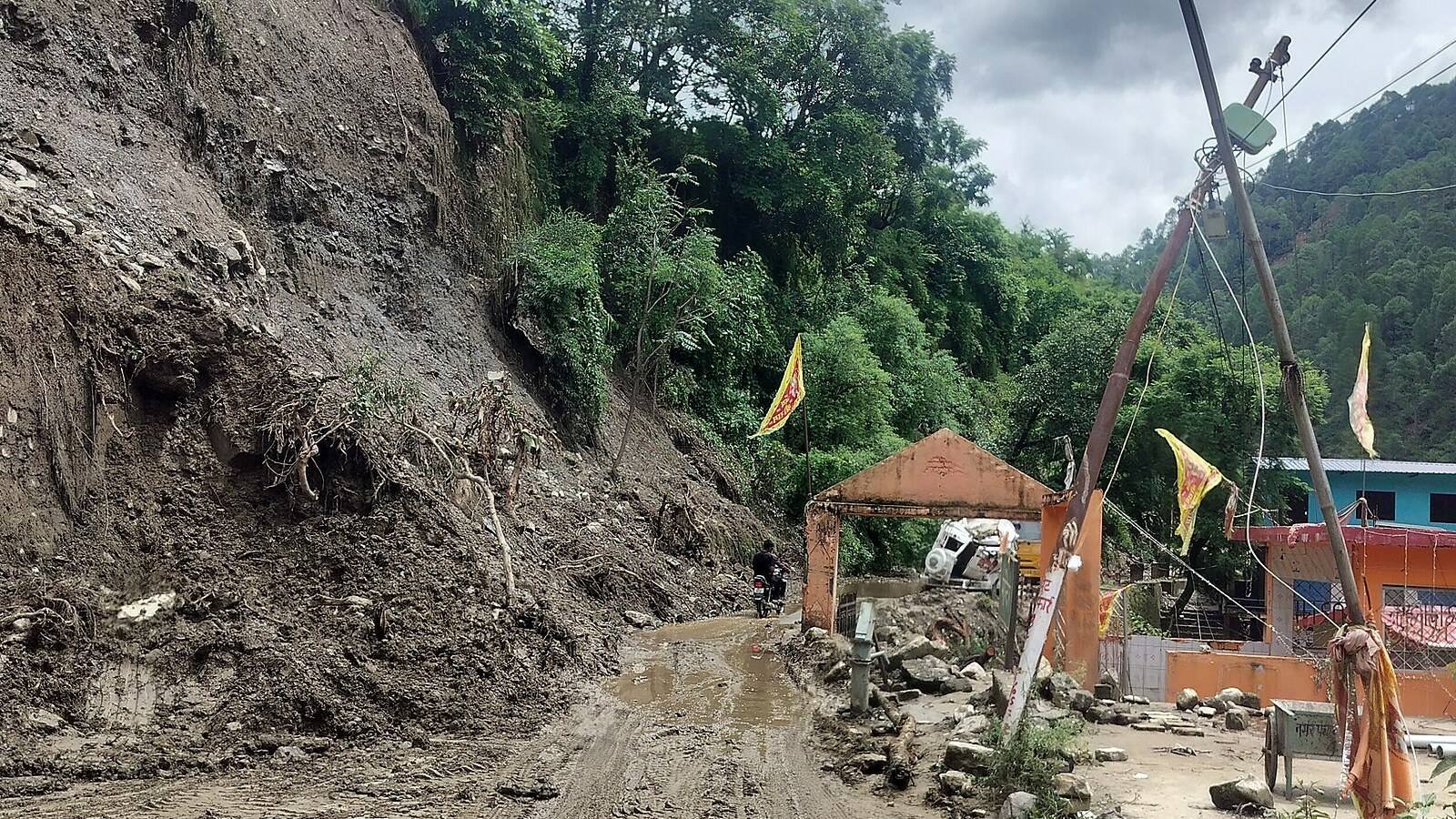
The four approach roads, going into 2027
Four roads leave Rishikesh and share nothing beyond the first forty kilometres to Devprayag. This is their condition as the 2026 season ends. The buffer is the extra time a realistic plan carries on that leg during the monsoon months, not a worst case.
| Route | Highway | Distance from Rishikesh | What 2027 drivers hit | Buffer to carry |
|---|---|---|---|---|
| Rudraprayag → Sonprayag → Gaurikund (Kedarnath) | NH-107 | 140 km to Rudraprayag, then 75 km to Gaurikund | Sirobagad before Rudraprayag; Munkatiya and Bhimbali above Sonprayag; no road for the last 5 km | A full day |
| Rudraprayag → Karnaprayag → Joshimath → Badrinath | NH-07 | About 295 km | Sirobagad, then 10 km of damaged road above Joshimath released in 30-minute batches | A full day |
| Dharasu → Uttarkashi → Gangotri | NH-34 | About 155 km to Uttarkashi, 100 km on to Gangotri | Nalupani and Dabrani in the gorge, Netala near the end; rockfall rather than deep slides | Half a day |
| Dharasu → Naugaon → Barkot → Janki Chatti (Yamunotri) | NH-134 | About 220 km | Syanachatti and Silai Band, then 45 km of single lane above the Yamuna; the least-finished highway | Half a day to a full day |
Two are the ones to watch. NH-107 and NH-07 share the sixty kilometres from Devprayag through Srinagar to Rudraprayag, and Sirobagad sits in the middle of it — so one slide there stops both dhams’ traffic in the same queue. NH-134 is the other: least all-weather work completed, most monsoon closures, and the only one where the road itself washed away rather than being buried.
What the 2026 monsoon actually did
The 2026 monsoon was not a wet one by the totals. IMD closed the season on 30 September at 87 per cent of normal nationally — 759.4 mm against 868.6 mm, a 13 per cent deficit and the first deficient season since 2015. Uttarakhand started drier still, a 32 per cent deficit by 21 June, with the monsoon reaching most of the state around 30 June, about ten days late.
None of which helped the roads, because damage comes from intensity, not totals. Three days of cloudburst-grade rain above a highway does what a normal month does not. Here is the 2026 record, which is the closest thing to a 2027 forecast:
| Date | What happened | Where | How long |
|---|---|---|---|
| 2 July | Debris buried the highway, hundreds of vehicles stranded; Adi Kailash and Om Parvat permits suspended | Sirobagad, NH-07 | Most of a day |
| 9–11 July | A slide washed away nearly 100 m of road; about 100 pilgrims walked across an alternative path on a rope | Syanachatti, NH-134 | Two days |
| 10–11 July | Repeated debris at two points; cleared and blocked again within hours | Nalupani and Nagoon, NH-34 | Hours at a time |
| 11 July | Fresh slide; ANI reported seven hours, The New Indian Express about ten, with queues of nearly 10 km each way | Sirobagad–Khankra, NH-07 | 7–10 hours |
| 20 July | Yatra halted on red and orange alerts; pilgrims on the road held at shelters and not allowed onward | All four routes | One day |
| 28 July | A 25–30 m stretch of the pilgrim path subsided 2–2.5 m after the river rose; the same morning a slide at Hanuman Barrier killed one resident and injured a second man | Janki Chatti–Yamunotri path; Sonprayag, NH-107 | Path shut for repairs |
| 28–29 July | Whole yatra suspended; 111 roads closed statewide including three national highways and six state highways | All four routes | Two days |
| Late July | Night slide at Munkatiya stranded pilgrims both sides; 10,450 moved across the debris by SDRF and district teams | Sonprayag–Gaurikund, NH-107 | Cleared next day |
| 6 August | Gangotri and Yamunotri highways blocked at four points; Gangotri reopened for small vehicles at Papdagad while heavy vehicles waited | Nalu Pani and Papdagad (NH-34); Silai Bend, Durbil, Syanachatti (NH-134) | Hours to a day |
| 23 August | Overnight rain brought boulders onto the highway before 8:00 AM | Netala, NH-34 | Temporary |
| 26–27 September | Two-day suspension; Sirobagad buried the road again near Dhari Devi, about 4,000 pilgrims stranded, Kedarnath yatra halted until further orders | All four routes; Sirobagad, NH-07 | Two days, resumed 28 September |
| 26 October | Trial movement began on the Rudraprayag bypass tunnel and bridge; formal inauguration still pending as the season closed | Rudraprayag, between NH-107 and NH-07 | Permanent, once opened |
Read that for the pattern rather than the drama. Three formal suspensions, five days lost in a two-hundred-day season. Nine major highway blocks cleared inside a day. One stretch, Syanachatti, that took two days because the road had to be rebuilt rather than swept. A bad-news monsoon for a pilgrim looks like four or five unplanned afternoons, concentrated in the six weeks either side of mid-July.
The slide register: the stretches that will close in 2027
Every closure in that table landed on a stretch that has been closing for years. This is the list worth knowing by name, because it is what a driver means by “bad ahead” — and because two entries now have a permanent fix with a date on it.
| Stretch | Highway | Where | 2026 record | Typical closure | Fix under way |
|---|---|---|---|---|---|
| Sirobagad | NH-07 | Srinagar to Rudraprayag, near Dhari Devi temple | Blocked 2 July, 11 July and 27 September; the last halted the Kedarnath yatra and stranded about 4,000 pilgrims | 6–24 hours; two days in September | Kaliyasaur–Khankra bypass, 3.22 km, ₹126 crore, target May 2027 |
| Munkatiya | NH-107 | Above Sonprayag on the climb to Gaurikund | Night slide stranded pilgrims both sides; 10,450 moved across the debris | 2–8 hours | Slope protection on Rudraprayag–Gaurikund |
| Hanuman Barrier | NH-107 | Sonprayag town | 28 July slide killed one local resident, injured a second man; no pilgrim casualties | Hours | Retaining structures; no bypass |
| Bhimbali | Kedarnath trail | Mid-way up the 16 km path | Walkable in October but repeatedly debris-covered; walkers, ponies and palkis routed separately | Hours on foot | Trail repair each season |
| Chirbasa | Kedarnath trail | About 2.5 km above Gaurikund | Slid repeatedly in September; the least stable short section of the path | Hours, on foot only | Path re-cut; no road possible |
| Syanachatti, Silai Band | NH-134 | Yamuna valley between Naugaon and Barkot | Nearly 100 m washed away 9 July, two-day cut, rope evacuation of about 100 pilgrims; blocked again 6 August | Two days when the road is lost | New Yamuna bridge ordered July 2026; ₹233 crore for 17 sites |
| Sarigad, Durbil | NH-134 | Above Barkot, Pali Gad to Janki Chatti | Repeated rockfall through August and October kept the last 45 km stop-start | 3–12 hours | Same 17-site improvement package |
| Nalupani | NH-34 | Dharasu to Uttarkashi | Blocked in July and on 6 August; the district magistrate ordered a JCB stationed permanently at the spot | 2–6 hours | Standing machine, not a bypass |
| Dabrani, Netala | NH-34 | Uttarkashi to Gangotri, gorge and final 30 km | Netala blocked before 8:00 AM on 23 August; rockfall at Dabrani injured a passing pilgrim in late October | 1–4 hours | BRO slope work and rockfall netting |
| Joshimath–Marwari | NH-07 | Immediately above Joshimath | About 10 km very poor after the town’s subsidence; gate near Narsingh temple releases traffic in 30-minute batches, queues 7–8 km | 1–3 hours, daily | Repair and stabilisation; no bypass exists |
| Helang, Lambagad | NH-07 | Joshimath to Badrinath, including the last climb | Helang blocked by debris on 6 August; Lambagad remains the late-season rockfall point above the temple | 2–8 hours | Rockfall protection on the final 45 km |
Two fixes matter more than the rest. The Kaliyasaur–Khankra bypass — 3.22 km, three bridges, two over the Alaknanda at 182 m and 189 m — is built specifically to take traffic off Sirobagad, with completion put at May 2027 after one bridge stalled four years. The Rudraprayag bypass, a 900.30 m tunnel and 200 m bridge, routes traffic around the town market and took its first trial vehicles on 26 October 2026. Neither removes a landslide; both remove the queue, which is often the bigger delay.
Kedarnath: the five kilometres that decide your day
The Kedarnath road ends at Sonprayag for private vehicles, five kilometres short of Gaurikund, and those five kilometres are where a Kedarnath day goes wrong. They climb above the Mandakini through Munkatiya, where a night slide in late July 2026 left pilgrims trapped on both sides until earth movers cleared it — 10,450 people were walked across the debris. The district magistrate’s report is instructive: “a minor landslide … most of the debris was cleared by last evening itself,” traffic normal the next day. A minor slide, ten thousand people, one day.
So do not treat those 5 km as a transfer: build in the chance that it takes ninety minutes instead of twenty, and that the shared-jeep queue at Sonprayag forms before light. Above Gaurikund there is no road, so the 16 km trail is the only alternative, and the trail has its own problem sections at Bhimbali and Chirbasa — which is why police ran walkers, ponies and palkis on separate lines through Bhimbali in October 2026.
Helicopters do not solve it. Shuttle flights run from Sirsi, Phata and Guptkashi, and in 2026 the last window closed on 9 November, two days before the temple, so a late-season plan that depends on a flight is the first thing a snow forecast takes away. Price the road-and-trek version against the Kedarnath guide.
Badrinath: Sirobagad, Joshimath, and ten kilometres that are not a road
Two bottlenecks sit on the Badrinath approach and neither is at the temple. The first is Sirobagad, which is not really on the Badrinath road at all — it is on the shared Rishikesh–Rudraprayag stretch, which is why a slide there stops Kedarnath traffic too. It has been the circuit’s most reliable closure for close to three decades, and 2026 delivered it three times, the last burying the road near Dhari Devi and putting the Kedarnath yatra on hold.
The second is above Joshimath. Chamoli’s superintendent of police described it plainly during the season: about 10 km of the Joshimath–Marwari–Vishnuprayag stretch is in very poor condition because of the town’s subsidence, so a gate near the Narsingh temple releases traffic in 30-minute batches, one direction at a time. At peak 30,000 to 35,000 pilgrims a day were heading to Badrinath, plus 5,000 to 10,000 to Hemkund Sahib. The queue reached 7–8 km from the Joshimath petrol pump through Marwari Chowk to Jogidhara, with waits of one to three hours.
Leave Joshimath before 7:00 AM, in whichever direction the gate is releasing first. Coming down from Badrinath and hoping to reach Rudraprayag the same day, that gate costs an hour you did not budget, and a nine-to-ten-hour drive becomes eleven. Badrinath is also the last shrine to close — 16 November 2026 at 9:37 PM — which makes the Alaknanda road the only one still carrying pilgrims into the third week of November.
Gangotri and Yamunotri: rockfall in one valley, a missing road in the other
The Gangotri road fails shallow and often. NH-34 runs up the Bhagirathi through a gorge where the hillside is steep, the road is cut into it, and debris arrives without warning: Nalupani and Nagoon in July, Papdagad in August, Netala before breakfast on 23 August, Dabrani in late October where rockfall injured a passing pilgrim. The district magistrate’s answer to the repeat offenders was unglamorous and effective — a JCB stationed permanently at Nalupani. Expect two to six hours, not two days.
The Yamunotri road fails differently, and worse. NH-134 from Dharasu through Naugaon and Barkot to Janki Chatti is the least complete highway on the circuit, and in 2026 it did what no other route did: it lost its own surface. A slide at Syanachatti on 9 July washed away nearly 100 m, cut the highway for two days, and left about 100 pilgrims to be escorted across an improvised path on a rope; the district magistrate then ordered a bridge over the Yamuna at the same spot within a week. Then the pilgrim path went too: on 28 July a 25–30 m stretch near Ram Mandir subsided 2–2.5 m when the river rose and was declared unsafe.
That combination — a single-lane valley road with a bridge dependency, plus a walking path that can subside — is why the Yamunotri leg deserves a full buffer day rather than half of one. The Centre sanctioned ₹461 crore on 4 April 2026 for this class of work, ₹233 crore of it for 17 slide-prone sites on NH-134 in Uttarkashi district, but slope treatment is not a 2027 delivery. Drive the leg in the morning and be at Janki Chatti by noon.
Buffer days: how many, and where they go
A buffer is not padding; it is the difference between missing one darshan and missing the circuit. These numbers are calibrated to what 2026 delivered, on the standard 9-day itinerary out of Haridwar.
| Window | What the 2026 record shows | Buffer to add |
|---|---|---|
| Opening weeks, late April to early May | Roads being cleared of winter debris above the treeline; opening crowds; no monsoon slides yet | None, but no same-day arrival at Gangotri or Yamunotri |
| 20 April – 10 June | The clear window: no suspension orders, no highway lost | 0–1 day |
| 11–30 June | Monsoon arriving around 30 June, cloud every afternoon, first slides of the season | 1 day |
| July | Halted 20 July, suspended 28–29 July; Syanachatti lost 100 m of road on 9 July; Munkatiya stranded pilgrims in the last week | 2 days |
| August | No formal suspension, but four highways blocked on 6 August and Netala shut before 8:00 AM on 23 August | 2 days |
| September | Suspension 26–27 September; Sirobagad buried the road again; Chirbasa slid repeatedly | 1 day |
| 1–16 November, closing fortnight | Clear roads but snow at the shrines; one snow spell can shut the Gaurikund road for a day | 1 day, and no dependence on a helicopter |
Where the days go matters as much as how many. Put the first between Rudraprayag and Sonprayag, the leg with the most failure points and no substitute. Put a second, if you carry one, between Uttarkashi and Gangotri, because a Gangotri closure is a there-and-back road with no alternative approach. Do not put a buffer at Haridwar on the way home — that delays a train, which costs money, not a darshan.
What changes for 2027, and what will not
The 2027 season opens three weeks later than 2026, and that is the most useful fact here. Yamunotri and Gangotri open on Akshaya Tritiya, which falls on 9 May 2027 against 19 April in 2026; Kedarnath’s date is announced at Ukhimath on Maha Shivratri, 6 March 2027, and Badrinath’s at Narendra Nagar on Vasant Panchami, 11 February 2027. That gives the road agencies about 180 days — from the 10 November 2026 Gangotri closing to the 9 May 2027 reopening — to repair what the monsoon broke, and it compresses the good-weather window into nine weeks before the rain returns.
| Work | Scale | Status, November 2026 | What it changes for you |
|---|---|---|---|
| Char Dham Mahamarg Vikas Pariyojana, overall | 825 km of highway, ₹12,072 crore | 629 km complete, 76 per cent on PIB’s programme figures; the Yamunotri corridor least finished | Wider, better-drained road on most of the circuit; single-lane stretches wherever work is live |
| Kaliyasaur–Khankra bypass at Sirobagad | 3.22 km, ₹126 crore, three bridges | One of three bridges complete after a four-year stall; target May 2027 | If it opens on time, the most repeated closure stops holding both dhams at once |
| Rudraprayag bypass | 900.30 m tunnel, 200 m bridge, ₹156 crore | Trial movement from 26 October 2026; formal inauguration pending | Takes through-traffic out of the market bottleneck, not out of the slides |
| NH-134 slide treatment, 17 sites | ₹233 crore, sanctioned 4 April 2026 | Sanctioned and under way; slope work takes seasons, not months | Less rockfall on Barkot–Janki Chatti, but not a new road in 2027 |
| Landslide mitigation, statewide | 58 sites treated, 96 in progress, 104 at design stage | Ongoing across the hill districts, per MoRTH in June 2026 | Fewer small closures; treated slopes shed less debris each July |
| InSAR slope monitoring | 100 km of the Char Dham route | Piloted by MoRTH with satellite-based ground-movement detection | Earlier warnings and pre-emptive closures, which look like more closures, not fewer |
| Joshimath–Marwari repair | About 10 km of damaged carriageway | Gate system in daily operation; no bypass planned | The one-hour tax on every Badrinath day stays in 2027 |
The honest reading: 2027 will have a better road in more places and the same five bottlenecks. The programme has finished three-quarters of its length, but the last quarter is the high, steep, snow-fed part, and MoRTH’s own policy explains the pace there — new hill roads are now built in phases, with roughly a year spent cutting slopes and finishing protection works first, and road construction starting only after those slopes hold through one monsoon.
How to check the road on the morning you leave
Nobody in Uttarakhand plans a hill drive from a website. They plan it from a phone call and a police feed at breakfast, and you should do the same. Call the State Emergency Operation Centre on 1070 for statewide closures before a long leg, then the district control room on 1077 for the district you are actually standing in; 112 is for emergencies, not road queries. The three district police accounts on X — Rudraprayag, Chamoli and Uttarkashi — post photographs and closure notices within the hour, which is faster than any helpline. NHAI’s 1033 covers highway status and planned construction delays, and IMD Dehradun’s district-wise colour-coded warnings are what trigger the suspension orders in the first place.
A word on what “blocked” means in those feeds. A highway reported blocked at 9:00 AM is usually open by 2:00 PM; a highway reported blocked for two days means the surface is gone, not that it is buried. Ask which, because the answer decides whether you wait or reorder the dhams. For the wider picture, the month-by-month guide covers which weeks to avoid and the kapat dates page carries the 2027 opening picture as it stands.
Where this fits in your plan
Read this with the 2027 hub for dates and route order, the itinerary guide for the day-by-day loop the buffer table assumes, and the cost guide if a hotel or cab is quoting a monsoon premium. Travelling with someone who cannot walk far, the seniors guide prices the ponies and palkis that replace the trail; from Delhi, the Delhi guide covers the 220 km that has to go right first; and the packing list is what a wet road asks of you. For the dhams, start with Kedarnath, Badrinath, Gangotri and Yamunotri.
Frequently asked questions
Will the Char Dham roads be open in May 2027?
Yes, on the same pattern as 2026. Gangotri and Yamunotri open on Akshaya Tritiya, 9 May 2027, and the agencies have about 180 days from the November 2026 closures to clear winter debris and finish repairs. The opening weeks carry a different risk: incomplete snow clearance above the treeline and single-lane construction stretches, so the drive is slow rather than closed.
How many extra days should I add for landslides?
Two in July or August, one in September, none in the May–June window. That is calibrated to the 2026 record, when the yatra lost five days in total to formal suspensions while individual highways were blocked about a dozen times. Put the first buffer between Rudraprayag and Sonprayag, the leg with the most failure points.
Which road is worst: Kedarnath, Badrinath, Gangotri or Yamunotri?
Yamunotri’s NH-134 is the least finished highway and the only one that lost its own surface in 2026, when nearly 100 m washed away at Syanachatti. The worst single bottleneck is Sirobagad on the shared Rishikesh–Rudraprayag stretch, because one slide there holds Kedarnath and Badrinath traffic at once. Gangotri’s road fails often but clears fast.
Is the Kedarnath road open to Gaurikund?
To Sonprayag, yes, for all vehicles. The last 5 km from Sonprayag to Gaurikund is where private vehicles are stopped in season and shared jeeps take over — and that is the slide-prone stretch. Above Gaurikund there is no road: the final 16 km is trail, on foot, pony or palki.
What happens if a landslide blocks the road while I am on it?
You are stopped short of the debris, usually one to six hours while a machine clears it, and if it is late you stay where you are, because night movement is banned between 10:00 PM and 4:00 AM. Never stop inside a marked rockfall zone. If the surface is gone rather than buried, expect one to three days and change the order of the dhams.
Are the roads safe at night?
They are not open at night. Vehicle movement on the Char Dham routes is banned from 10:00 PM to 4:00 AM, enforced at barriers in Tehri, Devprayag, Muni Ki Reti, Dhalwala and Chamba, with fines under the Motor Vehicles Act. The department’s guidance is stricter still — no hill driving before 5:00 AM or after 7:00 PM — so plan every leg to be parked by 7:00 PM, which is what every operator on the circuit does anyway.
Does the Rudraprayag tunnel shorten the trip?
It removes a bottleneck rather than kilometres. The 900.30 m tunnel and 200 m bridge connect NH-107 with NH-07 so through-traffic can bypass the town market; trial movement began on 26 October 2026 and formal inauguration was pending as the season closed. Expect a cleaner junction, not a shorter drive.
Will the 2026 closures repeat in 2027?
The same stretches will close. Sirobagad, Munkatiya, Syanachatti, Nalupani and the Joshimath stretch have been failing for years, and slope treatment changes how often, not whether. What may change is duration: the Kaliyasaur–Khankra bypass at Sirobagad is targeted for May 2027, and if it opens, the most repeated closure stops blocking both dhams at once.
Do I need a special permit to drive the Char Dham roads myself?
Not for a private car, but there are conditions: the vehicle must be within the hill-route limits — wheelbase up to 4,225 mm, width up to 2,500 mm — carry valid documents and pass the trip-card check at the entry barrier, and every pilgrim needs registration (the URN) before darshan at Kedarnath and Badrinath. Commercial passenger vehicles need a Green Card issued after a fitness inspection, hired drivers are held to eight hours at the wheel in a day, and a checkpost will turn back a taxi without the card.
What is the single biggest delay risk in 2027?
Not a landslide — the Joshimath gate. About 10 km of the Marwari–Vishnuprayag stretch is in very poor condition after the town’s subsidence, and traffic is released in 30-minute batches, one direction at a time. At peak it produced 7–8 km queues and waits of one to three hours daily, on a road with no alternative approach. Leave Joshimath before 7:00 AM.
Distances are road distances from Rishikesh and grow with diversions. Closure times are the 2026 record as reported by the district administrations, the State Emergency Operation Centre and the national press, and they are indicative, not guaranteed — a slide that cleared in four hours in 2026 can take two days in 2027. Road works, gate timings and suspension orders change within a season: confirm on the morning you travel on 1070 or 1077. Landslide photograph by Nitin Maletha, CC BY-SA 4.0, via Wikimedia Commons; it shows the same slope-failure pattern at Tharali in Chamoli district, not the Char Dham highway itself.

1 comment on “Char Dham Road Conditions 2027: What the Monsoon Left”